handleiding
Features:
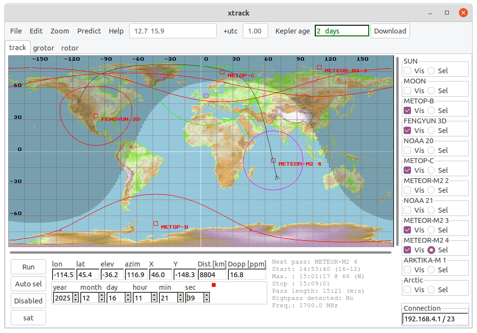
- Tracking of 1 or more satellites at a time, including sensor-mapping on earth (NOAA) and visual-range.
- Reads satellite data from norad-2 elements file.
- Download Kepler-data from Celestrak
- Handling max 4 Kepler files at a time
- Prediction next pass.
- Changing of satellite during "flight" possible.
- Changing of Kepler-data during "flight" possible.
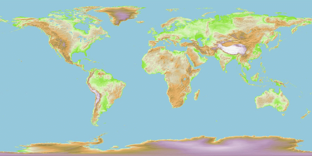
- Uses jpg or gif-file for background
- Preferences file
- Prediction of start, stop, length and max. elevation
- Generation of picture (postscript) for monthly overview
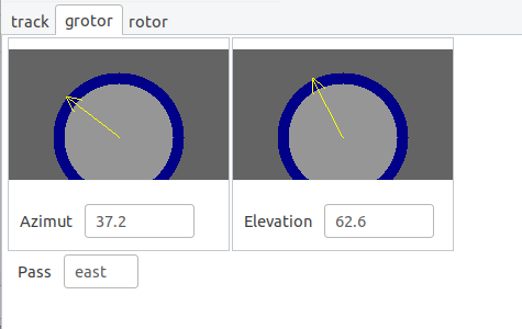
- Driving rotor system:
- RS232 output for feeding of rotor driving programs
- Commands to GODIL decoder: The HRPT decoder described elsewehere on my pages can also receive positions, which are then translated into DiSEqC commands.
- Support elevation/azimuth and X/Y rotors, with X or Y rotor at disc.
- Connection via Ethernet, also directly to accesspoint (e.g. rotorcontrol in ESP)
- Look ahead
- Debug functions
- Calculation colinearity geostat. satellite with SUN.Calc. position up to 10x per sec.
- Zoom function
Usage:
xtrack [options]
   [options:]
     -f     <norad-filename> (default: norad.txt or what's in xtrack.ini)

     -rlon  <ref-pos lon> (default: 5)
     -rlat  <ref-pos lat> (default: 52)
     -rep_time <repetition time> (default: 1.0)
     -run_at_start
     -log <log_file> : use logfile for rotor results

     -m     <map-filename> (default: earthmap.gif)
     -ppl   <value> (default:  2)
     -max_azimspeed <value> in degr/sec, show err in degrees; def=0=no limit: show speed (predict only)
  ppl=pixels per longitude.
  ppl=1 means: 1 pixel=1 degree, so size is 360x180 pixels.
These options (and more) may be put in a preferences file: xtrack.ini.
See menu 'Edit->Preferences'.
Ethernet connection using rotorcontroller with ESP processor
Normal way via local net
- Xtrack, Preferences:
- tab 'Run options': choose 'Use ethernet'
- tab UART/Ethernet: set IP to
, e.g. esp32-75EC4C
- esp module:
- use in 'no access' mode
- PC:
- use wired connection (PC-WiFi doesn't work for some reason???)
controller in esp=access point
- Xtrack, Preferences:
- tab 'Run options': choose 'Use ethernet'
- tab UART/Ethernet: set IP to 192.168.4.1
- esp module:
- use in 'access' mode
- Power-on
- PC:
- set wifi on SSID of esp (defined in esp-code)
- enter password (defined in esp-code)
Downloads:
| Version | Type | Download Linux 64-bits | Download raspberry Pi | Download Windows | Comment |
|---|---|---|---|---|---|
| 2026.2b | xtrack program | xtrack_2026_2b.tgz | setup_xtrack_2026_2b2.exe | Shown error message if download kepler fails
Download kepler: date is now checked with selected sat Windows: bug downloading tle fixed | |
| 2026.2a | xtrack program | xtrack_2026_2a.tgz | setup_xtrack_2026_2a.exe | "Compass" function
Better manual adaption of size window Some bugs fixed (2a: more bug fixes) | |
| 2026.1 | xtrack program | xtrack_2026_1.tgz | xtrack_arm64_2026_1.tgz | setup_xtrack_2026_1.exe | Simple one-click download of Keplers
Visualisation of rotor directions No need for separate jpeg812 libs (.so/DLL) |
| 2.0 | Needed DLL's | setup_gtk20dll.exe (2.6 Mbyte) | for all Windows releases, needed to download/install just one time | ||
| map of earth | earthmap.gif | other maps/resolutions possible, size must be 2:1 (x: -180...180, y: -90..90) | |||
Help for installation on Windows:
Example formatted pass:
In Preferences, tab 'Rotor drive', part 'Format track', define e.g.:- %H;%M;%S;%e;%a;%D;
In Predict (after selecting satellite(s) to show in main window):
- Predict
- Select satellite pass
- Click 'Save track selected'
06;23;42;3.043610;8.828597;3081;
06;23;43;3.105567;8.779921;3075;
....
Giving in csv-format Hours, Minutes, Seconds, elevation, azimuth and distance.
# seconds per line (or lines per second) depends on the 'Interval [sec]' to define in Preferences, tab 'Run options'.
Previous releases
| Version | Type | Download Linux 32-bits | Download Linux 64-bits | Download Windows | Comment | |
|---|---|---|---|---|---|---|
| 2025.3 | xtrack program | xtrack64_2025_3b.tgz | setup_xtrack_2025_3b.exe | Preferences: size of window can be adapted (tab 'colours, windows etc.') Adapt 'preferences' in esp controller (needs release 2025.1 of controller) | ||
| 2025.2a | xtrack program | xtrack64_2025_2a.tgz | setup_xtrack_2025_2a.exe | bug fix: kepler download command error (Windows) bug fix: rep. time, enable eth preferences issue follow sun: adapt east/west pass NOTE wget.exe not present, reuse/download/install if needed. (curl also supported) | ||
| 2025.1/1a | xtrack program | xtrack64_2025_1.tgz | setup_xtrack_2025_1a.exe | Added support xml besides tle In predicted pass file: %F for Doppler shift | ||
| 2023.2b_beta | xtrack program | xtrack64_2023_2b_beta.tgz | setup_xtrack_2023_2b_beta.exe | Added location sat. from Horizons System | ||
| 2023.2b | xtrack program | xtrack32_2023_2.tgz | xtrack64_2023_2.tgz | setup_xtrack_2023_2.exe | Added Ethernet with acesspoint in rotor control Uses curl or new wget for downloads. | |
| 2021.4c | xtrack program | xtrack_2021_4c.tgz | xtrack64_2021_4c.tgz | setup_xtrack_2021_4c.exe | Added search portnr.: menu 'Help->Search portnr' Extra detection 'rotorcontroller attached' added Fixed show trackercontroller parameters 64-bits: currently no decoder connection possible, for diseqc-rotors | |
| 2021.3 | xtrack program | xtrack_2021_3.tgz | setup_xtrack_2021_3.exe | Added popup window to show trackercontroller parameters Fixed tracking sat next to previous sat with overlapping pass 64-bits: currently no decoder connection possible, for diseqc-rotors | ||
| 2021.2 | xtrack program | xtrack_2021_2.tgz | xtrack64_2021_2.tgz | setup_xtrack_2021_2.exe | Added usage of multiple norad files (up to 4) Apply offset to rotors (use e.g. for calibration on geostat. satellite) 64-bits: currently no decoder connection possible, for diseqc-rotors | |
| 2021.1 | xtrack program | xtrack_2021_1.tgz | setup_xtrack_2021_1.exe | Added look-ahead, add offset during tracking | ||
| 2020.2 | xtrack program | xtrack_2020_2.tgz | setup_xtrack_2020_2.exe | Added feedback from rotor about actual position; calc. dot-product | ||
| 2020.1 | xtrack program | xtrack_2020_1.tgz | setup_xtrack_2020_1.exe | SGP4 enhanced ("official" code used)
Flattening earth taken into account predict only: define max. azim. speed (simulates effect of too slow rotor) | ||
| 2019.1 | xtrack program | xtrack_2019_1.tgz | setup_xtrack_2019_1.exe | Added: create user-formatted list of pass | ||
| 2018.4a | xtrack program | xtrack_2018_4.tgz | setup_xtrack_2018_4.exe | Added separate 'observer radio horizon' debug: aim to "satellite" at some fixed location | ||
| 2.0 | Needed DLL-libs | setup_gtk20dll.exe (2.6 Mbyte) | for all releases, needed to download/install just one time | |||
| 2006.09 | jpeg lib | decompr_k2.6.tar.gz | decompr64.tgz | jpeg-dll in setup_xtrack |
Xtrack for Pi
| Version | Type | Download Linux ARM 64-bits | Comment |
|---|---|---|---|
| 2025.1 | xtrack program | xtrack_arm64_2025_1.zip | Compiled on Ubuntu, Pi4 (64bits ARM) contains also libjpeg812.so and earthmap.gif |
Download Linux:
| Version | Type | Download | Download size | Comment |
|---|---|---|---|---|
| 2018.3a | xtrack program | xtrack_2018_3a.tgz | 102k | offset elev/azim/x/y |
| 2018.2 | xtrack program | xtrack_2018_2.tgz | 102k | distance added direct 'disable limit' for DiSEqC rotors in debug wnd |
| 2018.1 | xtrack program | xtrack_2018_1.tgz | 102k | Sun shadow settings in preferences RS232 commands: allow spaces |
| 2017.2c | xtrack program | xtrack_2017_2.tgz | 102k | Added moon Choose and save colours |
| 2017.1c | xtrack program | xtrack_2017_1.tgz | 102k | determine east/west also if at already 'up' determine east/west for geosatat. sats keep sat-names in window right part window made a bit wider, can now be adjusted |
| 2006.09 | jpeg lib | decompr_k2.6.tar.gz | 142k | contains libjpeg812.so, needed for xtrack |
| background | earthmap.gif |
Xtrack needs the gtk2.0 library set; normally available on any Linux distribution.
Download Windows:
| Version | Type | Download | Download size | Comment | ||
|---|---|---|---|---|---|---|
| 2018.3a | xtrack program | setup_xtrack_2018_3a.exe also contains earthmap.gif and jpeg812.dll | 785k | offset elev/azim/x/y | ||
| 2018.2 | xtrack program | setup_xtrack_2018_2.exe also contains earthmap.gif and jpeg812.dll | 785k | distance added direct 'disable limit' for DiSEqC rotors in debug wnd | ||
| 2018.1 | xtrack program | setup_xtrack_2018_1.exe also contains earthmap.gif and jpeg812.dll | 785k | Sun shadow settings in preferences RS232 commands: allow spaces | ||
| 2017.2c | xtrack program | setup_xtrack_2017_2.exe also contains earthmap.gif and jpeg812.dll | 780k | Added moon Choose and save colours | ||
| 2017.1c | xtrack program | setup_xtrack_2017_1.exe also contains earthmap.gif and jpeg812.dll | 780k | determine east/west also if at already 'up' determine east/west for geosatat. sats keep sat-names in window right part window made a bit wider, can now be adjusted | ||
| 2.0 | Needed DLL-libs | setup_gtk20dll.exe | 2.6M | Self-installing | ||
Help for installation on Windows:
Download source code:
| Version | Type | Download | Size | Comment |
|---|---|---|---|---|
| 2018.4a | xtrack code | xtrack_src_2018_4.zip | 205k | see comments 2018.4 program downloads |
| 2017.1c | xtrack code | xtrack_src_2017.zip | 200k | December 2018: Fixed zip! |
| 2013.02 | xtrack code | xtrack_src_2013.zip | 62k | Includes support jpeg background |
| 2004.03 | jpeg8/12-bits code | jpeg812_src.zip | 381k | Independent Jpeg Group code, partly adapted to support both 8 and 12 bits/pixel |
| 2010.01 | xtrack code | xtrack_src2010.zip | 92k | Suitable for both gtk2.0 and gtk1.2. No jpeg support. |
Example graphical output: NOAA_16_4.pdf